Charleston SC Maps
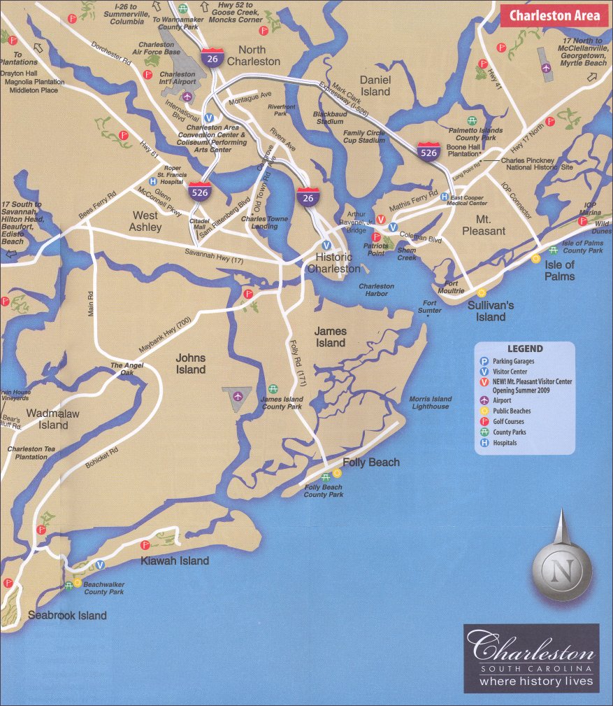
Find helpful Charleston SC Maps including points of interest maps, public restroom map, public parking garage map and restaurant maps.
The greater Charleston area is comprised of five regions: Mt Pleasant, West Ashley, North Charleston, The Islands, and Downtown Charleston.
- Mt. Pleasant - Mt. Pleasant is located just across the Arthur Ravenel Bridge and is home to Patriots Point and Boone Hall Plantation.
- West Ashley - This area is west of the Charleston Peninsula, across the Ashley River, and home to Drayton Hall and Middleton Place.
- North Charleston - North Charleston is located about 15 minutes north of downtown Charleston. The Charleston International Airport, Greyhound Bus Station and Amtrak Train Station are all located in North Charleston.
- The Islands - The Islands include Sullivan's Island, Isle of Palms, Folly Island, Kiawah Island, Seabrook Island, James Island, Daniel Island and Johns Island.
- Downtown Charleston - The Downtown Charleston Peninsula is about 17 square miles and home to antebellum mansions, museums, restaurants, shopping and quaint b&bs.

Below you will find some useful maps that will help you navigate around this historic city. Whether you are searching for nearby plantations, trying to locate public parking garages, or trying to locate the nearest public restroom, you will find the maps here.
Charleston SC Area Maps
- The Charleston Area Map gives an overview of the greater Charleston area, including the airport, nearby attractions, islands, beaches, and plantations.
- The Peninsula Map is useful because it focuses on the historic district, and highlights plenty of helpful information, including public parking garages and the routes for the free downtown area shuttle (DASH).
- Explore the islands in the area with the Charleston Islands Map.
- One of the most important maps is the Public Restrooms Map. Not all public restrooms in the downtown area are visibly marked or easy to find, so this map will help you locate them
Points of Interest Maps
- The Attractions map highlights the fun and exciting things you can see and do in Charleston, including museums, plantations, and historic homes.
- The beaches map will help you find all the nearby beaches, including Folly Beach and Isle of Palms.
- The Charleston parks map will help you locate all nearby parks, including the famous Waterfront Park and the bustling Marion Square Park.
- The historic churches map will help you locate all the historic houses of worship in downtown Charleston including The Circular Congregational Church and The Unitarian Church.
- The shopping map highlights the different shopping districts in downtown Charleston, and the art galleries map will help you locate the local art galleries in Charleston.
- The free things to do in Charleston map highlights 20 free places to visit and things to do in Charleston.
- The top 10 things to do in Charleston map will help you find something fun to see and do while visiting Charleston
Maps of Places to Stay in Charleston SC
- Find a romantic Bed and Breakfast in Charleston, SC with our bed and breakfast map.
- Find a charming inn or cozy boutique hotel with our historic inns map.
- Find first class service and luxurious accommodations with our map of luxury hotels.
- Find a convenient and affordable place to stay with our map of full-service hotels.
- Find a budget-friendly place to stay with our cheap hotels map.
- Find a place to pitch a tent or park your RV with our map of campgrounds in Charleston, SC.
Charleston SC Restaurants Map
- Find the Best Restaurants in Charleston
- Find the best "cheap eats" in Charleston
- Locate moderately priced restaurants in Charleston
- Locate fine dining restaurants in Charleston
Charleston SC Transportation Maps
- The DASH map highlights the routes of the Free Downtown Area Shuttle (DASH)
- The parking garage map highlights all the parking garages in downtown Charleston.
- Home
- About Charleston
- Charleston SC Maps
Copyright © 2009-2025 visit-historic-charleston.com


